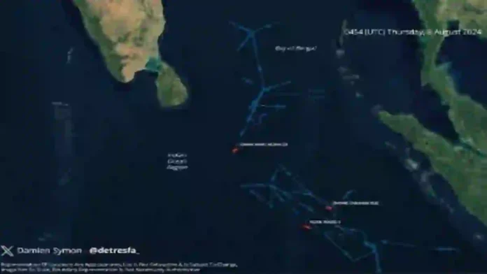
New Delhi: Three Chinese research vessels are currently operating in the Indian Ocean Region and are being tracked by the Indian Navy.
The latest satellite images show that these vessels – Xiang Yang Hong 03, Zhong Shan Da Xue and Ying Wang 7 – are in the neighbourhood.
UNESCO terms Zhong Shan Da Xue as a gigantic state-of-the-art floating laboratory that will help scientists discover the deep seas. It is China ‘s largest oceanographic research vessel at 114.3 metres long and 19.4 metres wide, with a total tonnage of 6,800 tons.
With a range of about 15,000 miles, the vessel can host 100 people — a crew of 24 as well as 76 scientific team members.
Xiang Yang Hong 03 is part of the latest class of research vessels and has several pieces of remote-sensing equipment to explore as deep as 10,000 metres.
While the Chinese claim that these are scientific research vessels, Indian as well as western authorities suspect it’s not quite that simple.
It is suspected the vessels are part of a larger ploy to gather data vital for conduct of naval operations, especially that of submarines, as mentioned earlier in a note prepared by the Indian Navy.
Read- DRDO Officials Conduct High-Level Review of TEJAS MK-2 Program
“Such unencumbered and suspicious activity within Sri Lankan waters will surely raise the hackles of other nations in the region and also has the potential to upset the delicate maritime balance in the IOR,” it said.
The Chinese ships are believed to be gathering information for naval planners — currents, bathymetry, salinity of the water — which are all relevant to submarine warfare.
The hydrographic data is civilian-defence agnostic, which means it can be used for both civilian and military purposes.
In an article published on Naval-News on 22 January, 2021 (‘Chinese Ships Seen Mapping Strategic Seabed In Indian Ocean’), defence and open-source intelligence analyst H.I. Sutton had written that some of the survey activities, nearer to Indonesia and the Andaman and Nicobar islands, could relate to finding the US Navy’s reputed “fish hook” sensor networks.
These networks are designed to track Chinese submarines entering the Indian Ocean.
Agencies


